<?xml version="1.0" encoding="UTF-8"?>
<feed xmlns="http://www.w3.org/2005/Atom">
  <title type="text">Harrisburg Historical</title>
  <updated>2026-09-25T22:02:52+00:00</updated>
  <generator uri="http://framework.zend.com" version="1.12.20">Zend_Feed_Writer</generator>
  <link rel="alternate" type="text/html" href="https://harrisburghistorical.org/"/>
  <link rel="self" type="application/atom+xml" href="https://harrisburghistorical.org/items/browse?output=rss2"/>
  <id>https://harrisburghistorical.org/</id>
  <author>
    <name>Harrisburg Historical</name>
    <uri>https://harrisburghistorical.org</uri>
  </author>
  <link rel="hub" href="https://pubsubhubbub.appspot.com/"/>
  <entry>
    <title type="html"><![CDATA[Restrictions on Locust Street: Building Homes to Build Fences]]></title>
    <summary type="html"><![CDATA[<p><strong><em>In the 1920s and 1930s, communities of Harrisburg and its surrounding boroughs and townships increasingly limited access of African American and immigrant residents to settle in specific neighborhoods. These restrictive covenants, common throughout the capital region, created channels of segregation with long legacies.</em></strong></p><img src="https://harrisburghistorical.org/files/fullsize/df2ef035724adb6db6f753aef8a470de.jpg" alt="HOLC Zoning Map of Harrisburg" /><br/><p>"It is a part of the consideration hereof, that the grantee, his heirs, executors, administrators or assigns, or his successors in title, shall not sell or lease to any but the Caucasian race." So stated the housing contract made between two Harrisburg citizens in November of 1926 concerning a property on Locust Street south of the capitol. As part of an official sale, this clause contains a restriction that limits the occupants of said property indefinitely to white buyers only. Racially restrictive covenants like this began to appear in Harrisburg and surrounding suburbs during the 1920s and, by the late 1930s, were common in cities across the nation. At a time when pre-existing racial divisions drew distinctive lines between neighborhoods, restrictive housing covenants of this kind were employed to ensure these lines were impassable for non-whites.
Restrictions in the deeds of sale of American homes and property were nothing new in the 1930s. Dating back at least to the early 19th century, property owners and developers used restrictive covenants—legal provisions in deeds that limited how property could be used, developed, or transferred—to bind buyers and even future owners to certain conditions of property usage. A deed might regulate fences, building setbacks, construction materials, or allowable uses of the property. Racial restrictions were a later form of this legal mechanism that worked to regulate the race of those who could own, lease, or occupy a property.
The Locust Street covenant was located in Harrisburg’s Third Ward near the riverfront on a brief stretch of road connecting Front Street to Third Street. In the 1920s, this area included mixed residential housing, businesses, churches, and community centers such as the Young Men’s Christian Association. However, it also lay in close proximity to the railroad and other industrial factories. Ward Three had a population of 88.5% white and 5.7% Black in 1920, but by 1935 had only 68% native white and 8.9% Black. That same year the population was described as “Capitol employees and transients in rooming houses.” With a slowly growing population of immigrants, industrial workers, and other non-whites pressing up against wealthier Front Street residents, Locust Street became a connector between two worlds: one predominantly white upper-middle class and the other an increasingly non-white working class of Wards Three and Four.
The Locust Street property was on the very edge of the white area and had been sold with a racially restrictive covenant in 1923. In other examples of racially restrictive covenants from this time, the restriction appears in a list with other stipulations such as fence length, size of yard, and types of trees allowed to be planted. When this property was resold in 1926, however, the racial clause was the only restriction in the contract. Since it sat on the border between white and Black neighborhoods, this property acted as a fence. The Locust Street deed is an early example of how racial restrictions were utilized in individual contracts as an obstacle to African Americans who wished to cross color lines. This contract, in fact, predates by roughly nine years a nationwide movement to create similar long-lasting barriers for African American home buyers, suggesting that local property owners and real-estate actors were already constructing racial barriers before federal housing policy systematized these practices in the 1930s
Restrictive covenantal language increased after 1935 when, under President Franklin Roosevelt’s New Deal, the Home Owners Loan Corporation (HOLC) was created (Rothstein, <i>The Color of Law</i>, 2017). In conjunction with the Federal Housing Association (FHA), the HOLC evaluated insurable zones in cities across the country and issued mortgages that included both principal and interest in payments. This enabled poorer Americans in areas of low insurance risk to purchase housing and accrue equity.
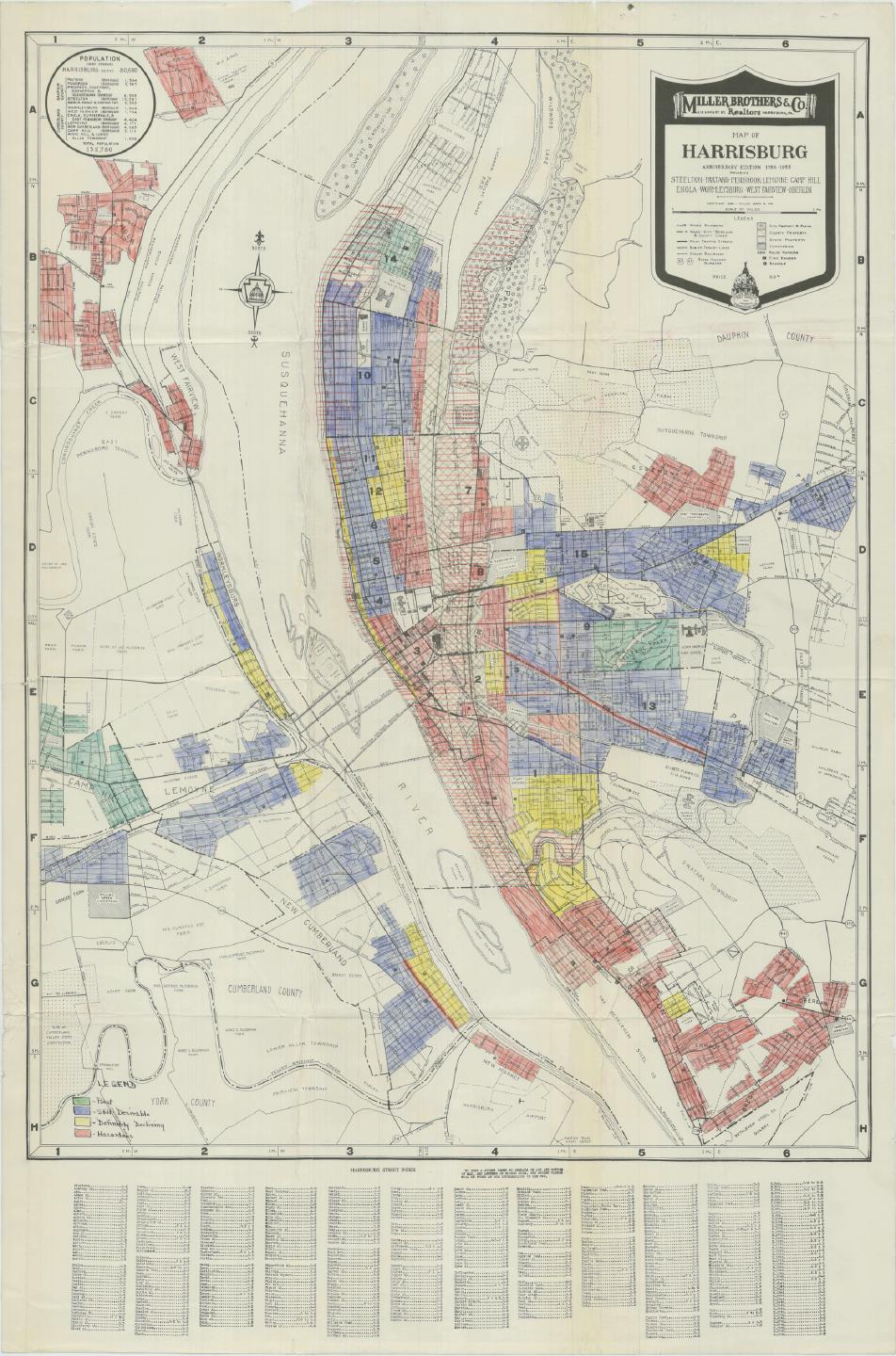
The HOLC outsourced its loan risk evaluations to local real estate agents who surveyed their home city and created a risk map for each neighborhood. Color ratings were given to each area based on factors such as population type, amount of commercial and industry areas, home conditions, possibility of new construction, and “detrimental influences” such as “less desirable elements of the population.” These less desirable elements were usually cited as, but not limited to, “foreigners,” “negro and alien,” and “less desirable native whites.” Grades of risk included green (“best”), blue (“static”), yellow (“definitely declining”), and red (“hazardous”). Given authority to determine which neighborhoods were worthy of investment, these local agents had legal power to devalue existing non-white neighborhoods that they deemed “undesirable.” This process is now known as “redlining,” referring to the red color given to “hazardous” neighborhoods on the HOLC maps.
In Harrisburg, the work of assigning HOLC risk grades was carried out by five local real-estate professionals who were themselves active participants in the city’s housing market. Some of them clearly stood to benefit from redlining. William Nelson and William Hollinger, for example, had been in the process of creating new suburban developments just outside of the central city in the mid-1930s. Even as their surveys devalued the neighborhoods in the heart of Harrisburg, they attracted white citizens to their more expensive developments, which excluded Black buyers and sometimes non-native whites. They achieved this in two ways: high pricing and restrictive covenants. An advertisement for Hollinger’s development in Woodland Park in Paxton township lists house prices starting at $8000 ($188,420.90 today)—a sharp contrast with the housing costs of redlined working-class neighborhoods such as Wards Seven and Eight, which were $800–$2,500 ($18,842.09–$58,881.53 today). The advertisement for this development emphasizes that buyers could easily apply for FHA loans to finance a property. Residents of redlined, high-risk wards such as Seven and Eight, however, were unlikely to receive comparable loans.
Although the price of housing was not itself a direct deterrent to African American home buyers, restrictive housing covenants effectively segregated new communities from the rest of the city. Hollinger Realty Co. and Nelson Investment and Development Corporation marketed suburban developments as a haven for middle and upper-class whites; through carefully placed racial restrictions, they were able to ensure this exclusivity. Colonial Park in Susquehanna, which began construction in 1936, has twelve (known) restrictive covenants. Nelson’s company issued nine known covenants and Hollinger’s issued at least twenty, all in new suburban communities or on borders between higher-rated communities and their redlined neighbors.
Some sixty discovered covenants in Harrisburg seem to lie on borders between a higher and lower-ranked neighborhood or in clusters within suburban developments. For example, there were at least four covenants in the central city that sit on borders between majority white (shown in blue/yellow) and majority African American (shown in red) communities. Suburban neighborhoods surrounding the city tended to have large clusters of restrictive covenants: dense clusters existed in areas like Lower Paxton Township, Progress Township, and Camp Hill. In this way, racially restrictive covenants became a border surrounding white suburbia that was nearly impassable to African Americans and non-native whites living in lower-income areas.
Racially restrictive covenants became unenforceable after the Supreme Court's Shelley vs. Kraemer decision (1948), and the Fair Housing Act of 1968 made racially restrictive covenants illegal more broadly. These acts, however, did nothing to retroactively repair the divisions covenants created. Maude Coleman, an Interracial Board and Pennsylvania Department of Welfare member, had been displaced twice because of Capitol extension projects, and her community north of the Capitol Park was at risk of being destroyed again. She <a href="https://harrisburghistorical.org/files/show/28">wrote to the Pennsylvania governor</a> in 1950 saying, “Our position, Governor Duff, is not like that of other groups. It is absolutely impossible for us to rent or buy property in Harrisburg in any decent neighborhood because of all kinds of restrictions. Certain districts are designated zones for Negroes, and there seems to be an unwritten law against them living anywhere else.” Though people such as Coleman lobbied for more equal treatment within the housing market, Harrisburg’s opportunities for home ownership continued to bleed into the outskirts while barricading the center.
The selling party on Locust Street in this case may not have been aware of the greater movement they participated in, but racially restrictive housing covenants like theirs perpetuated a systemic gap in access to decent housing and, by extension, generational wealth between white and Black residents. As recently as 2002, African American residents in the capital area reported that realtors discouraged them from purchasing property on the western shore of the Susquehanna, which historically hosted several racially restrictive neighborhoods (Loewen, <i>Sundown Towns,</i> 2018). At the same time, the most impoverished areas of the city align with the same areas deemed “undesirable” nearly 100 years ago by the HOLC maps. Restrictive covenants were not the sole factor that limited African American movement within and outside of Harrisburg, but clearly acted as legal fences, inhibiting Black social and physical advancement.
A full list of resources used in this story can be found <a href="https://www.zotero.org/groups/5114087/harrisburg_historical/collections/5CNEH4GC/collection">here</a>.</p><p><em><strong><a href="https://harrisburghistorical.org/items/show/35">For more (including 5 images) view the original article</a></strong></em></p>]]></summary>
    <published>2026-04-19T02:31:38+00:00</published>
    <updated>2026-09-25T22:02:52+00:00</updated>
    <link rel="alternate" type="text/html" href="https://harrisburghistorical.org/items/show/35"/>
    <id>https://harrisburghistorical.org/items/show/35</id>
    <author>
      <name>Molly Elspas</name>
    </author>
  </entry>
  <entry>
    <title type="html"><![CDATA[Maude Coleman and the Case Against Harrisburg&#039;s Second Capitol Extension : The Defense of the Seventh Ward ]]></title>
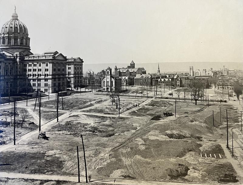
    <summary type="html"><![CDATA[<p><strong><em>In 1950, the prominent Maude Coleman, Interracial Consultant for the Commonwealth of Pennsylvania, wrote a letter to Governor James Henderson Duff advocating for the rights of Black homeowners of the Seventh Ward. In it, Coleman continued her fight to combat the state's seizure of property in her neighborhood.</em></strong></p><img src="https://harrisburghistorical.org/files/fullsize/7ee4dec21fd47f765423d3bfb6630a06.jpg" alt="Walnut and Short Looking North Toward Capitol, January 4, 1918" /><br/><p>In the first half of the twentieth century, during a time of radical change and social upheaval following the Reconstruction period, urban African American communities found themselves at a crossroads of uncertainty. The multiethnic neighborhoods east and northeast of the Pennsylvania State Capitol Building had faced similar circumstances through the First and Second Capitol Extension Projects carried out by the State legislature between the 1910s and 1950s. Those living in these neighborhoods did not capitulate without a fight, with one individual in particular, a community organizer named Maude Coleman, publicly writing to the state governor to affirm the value of her home and those of her neighbors. The letter to the Second Capitol Extension project renewed awareness of the unjust seizure of property in the diverse communities within the City of Harrisburg. </p><p>The appropriation of neighborhoods for the construction of Pennsylvania government buildings took place during multiple decades, beginning in the early twentieth century. North Street formed the divider between the destruction of properties in the "First Capitol Extension" and the "Second Capitol Extension." The first extension was passed by an act of the Pennsylvania Assembly in 1911 and claimed the section of the Old Eighth Ward defined by today's Walnut Street, Seventh Street, North Street, and Commonwealth Avenue. The Capitol Park Extension Commission invested thirty-six million dollars post-1913 to demolish twenty-nine acres (and 538 buildings) east of the Capitol building to create new state government buildings and recreational land by the early 1930s. In 1941, the Capitol Grounds Extension Planning Committee led by J. Horace McFarland outlined a proposal for a second extension and the acquisition of twenty-three more acres between North Street and Forster Street, from Third to Seventh Street across the northeastern corner of the Fourth Ward, and most of what remained of the Old Eighth Ward. This area contained 334 properties with 176 specific owners and a sizable residential population, of whom 50 percent were African Americans. Further extensions in the 1950s claimed neighborhoods north of Forster Street in the southern part of Harrisburg's Seventh Ward.</p><p>It was not uncommon for local, state, or federal officials to factor in race for urban planning efforts during the early to mid-twentieth century. Often, city planners applied generalized stereotypes of poor living conditions in diverse communities to accomplish their goals. In the case of the communities outlined for the initial phase of the Second Extension, the 1935–1936 Home Owners’ Loan Corporation survey noted that the homes between Third and Sixth Street possessed “considerable new paint and good exteriors” as opposed to remaining sections of the Old Eighth Ward to the east which was “run down [and] neglected” and was occupied by “alien white, negroes, and less desirable native whites.” In the planning report, these supposedly run-down homes were labeled as fire hazards (27 percent), with around 30 percent having outdoor plumbing. The planners also outlined other reasons to justify why the location should be purchased, including the improvement and widening of roads to ease traffic and to replace substandard buildings with favorable land for future construction projects. </p><p>The report prepared by the Capitol Grounds Extension Planning Committee was expansive, covering the usability of the extension area; the status and quality of its buildings and owners; the cost factors relating to how properties were to be acquired; the ways in which their project was to be financed; external legal aspects, the block plan; and a seven-step list of ways the extension area was to be further developed. Even still, the document does not offer any specific evidence regarding the social, cultural, or genealogical characteristics of those who lived in the second extension properties. There is, however, a blueprint of the area with a corresponding list of all the property owners as of 1930 (see Plan of Properties, below).</p><p>The Second Capitol Extension began in early 1942, one year after the report’s publication and twelve years after the 1930 property assessment blueprint. During the next decade, the Pennsylvania government seized properties in the designated area north of the Capitol Complex, but also expanded well beyond the originally planned district into the neighborhood of the Seventh Ward north of Forster Street. When Maude Coleman received a notice that the Capitol Park Extension planned to confiscate houses on her own block to create office space for the Department of Labor and Industry, she shared her feelings with then-Pennsylvania Governor James Duff. </p><p>Coleman was born in 1879 and lived briefly in the Old Eighth Ward until the First Capitol Extension claimed her property in 1912. Later, Coleman lived on Boas Street in the Seventh Ward from 1920 to 1953. On February 20, 1950, Coleman sent a letter to Governor Duff on behalf of a friend. Coleman was familiar enough with Pennsylvania's governors because of her intermittent service as Interracial Consultant from 1924 to 1953. Coleman used her professional capacity to appeal to Duff on behalf of the predominantly African American community located in and around the Second Extension area. While not located in the area initially proposed in the 1930 report, her neighborhood on Boas Street lay just one block north of Forster Street and marked the target for new appropriations in the 1950s. Coleman’s letter to Duff argued that the conditions for African Americans to acquire (new) housing in Harrisburg were “absolutely impossible” due to unwritten restrictions within the city. Additionally, Coleman pointed out that the homes in the extension area were not slum houses as the Planning Commission labeled them. Some of the occupants of this neighborhood included “ . . . our only Negro druggist in Central Pennsylvania, a practicing physician, a mortician, the best tourist home for Negroes in the city, and State and city employees.” In her view, they numbered "among the best homes for Negroes in Harrisburg."</p><p>Maude Coleman’s plea for consideration was ignored. In the end, Coleman's home met the same fate as 500 other properties of the Fourth, Seventh, and Eighth wards removed during the execution of the First and Second Capitol Extensions. Coleman's house at 641 Boas Street became the parking lot north of the Pennsylvania Labor and Industry Building where, ironically, stands the Pennsylvania Worker Statue today — a sculpture designed to honor the state's working population. The construction of office buildings, parkland, the Pennsylvania State Museum, and the former site of the Pennsylvania State Archives has shrouded the histories of hundreds of residential properties like that of Maude Coleman beneath the administrative facilities of the state.</p><p>A full list of the resources used in this story can be found <a href="https://www.zotero.org/groups/5114087/harrisburg_historical/collections/H8H94BBI">here</a>.</p><p><strong>Related Stories</p><a href="https://harrisburghistorical.org/items/show/17">The Phyllis Wheatley YWCA</a></p><p><a href="https://harrisburghistorical.org/items/show/6">A Gathering at the Crossroads</a></p><p><a href="https://harrisburghistorical.org/items/show/15">Black Politics and City Beautiful</a></p><p><a href="https://harrisburghistorical.org/items/show/7">Green Book Harrisburg</a></p><p><em><strong><a href="https://harrisburghistorical.org/items/show/10">For more (including 5 images&#32;&amp;&#32;2 audio files) view the original article</a></strong></em></p>]]></summary>
    <published>2024-03-25T01:17:05+00:00</published>
    <updated>2026-04-17T19:49:02+00:00</updated>
    <link rel="alternate" type="text/html" href="https://harrisburghistorical.org/items/show/10"/>
    <id>https://harrisburghistorical.org/items/show/10</id>
    <author>
      <name>Kelan Amme</name>
    </author>
  </entry>
</feed>