The Second Capitol Extension of Harrisburg, Pennsylvania
The story of communal awareness and resistance to legislative urban reform and renewal.
Learn how one leader in Harrisburg's historic African American community fought to combat the unjust seizure of property in their neighborhood.
In the early twentieth century, during a time of radical change and social upheaval following the Reconstruction period, the lives of urban African American communities found themselves at a crossroads of uncertainty. The Old Eighth Ward, a multiethnic, multiracial community behind the Pennsylvania State Capitol Building, shared a similar fate through the first and second Capitol Extension Projects carried out by the State legislature between the 1910s and 1950s. Those living in the Old Eighth did not go out without a fight, with one individual in particular, a community organizer named Maude Coleman, publicly writing to the state governor to affirm the value of her home and her neighbors. The Maude Coleman Letter directed toward the Second Capitol Extension project established a renewed precedent for awareness of the unjust seizure of property within the diverse communities within the City of Harrisburg.
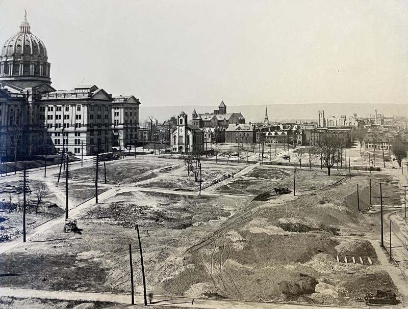
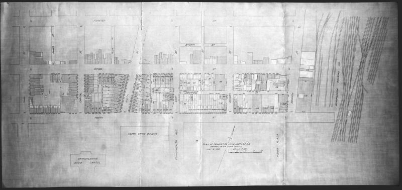
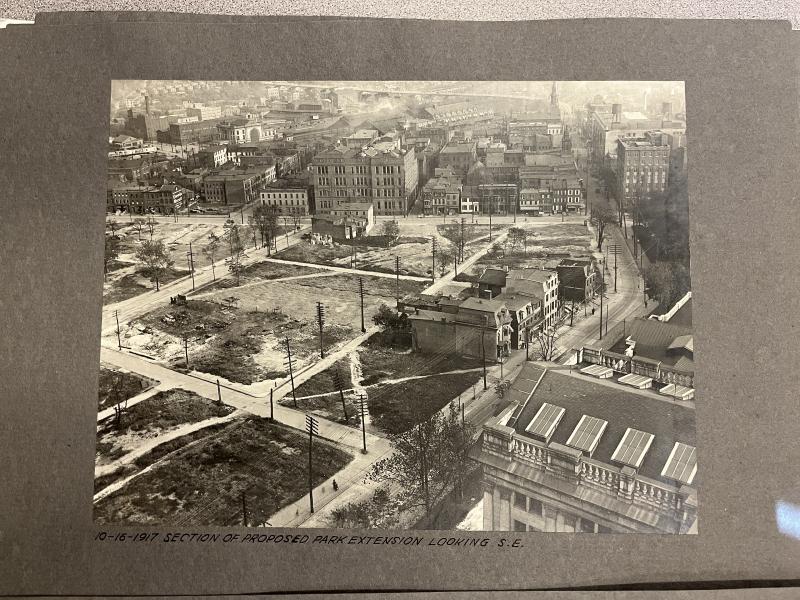
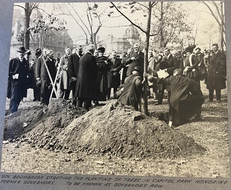
The intersection of Fourth and North Streets created the divider that designated the destruction of properties in the First and Second Extensions. The first extension was approved by the act of assembly in 1911 and was generally within the boundaries of modern-day Walnut, 7th, and Forster Streets and Commonwealth Avenue. The Capitol Park Extension Commission would invest 36 million dollars post-1913 to demolish 29 acres (and 538 buildings) east of the Capitol building to create new state government buildings and recreational land by the 1930s. In 1941, the Capitol Grounds Extension Planning Committee led by J. Horace McFarland outlined a proposal for a second capitol extension in the acquisition of 23 acres north of North Street that contained 334 properties with 176 specific owners. Of the occupants in this proposed extension, about 50 percent were African American.
It was not uncommon for local, state, or federal officials to factor in race to urban planning efforts during the early-mid twentieth century. Often, generalized stereotypes regarding living conditions were heightened by city planners, directed explicitly to communities with diverse populations. In the case of the Eighth Ward communities outlined for the Second Extension, the 1935-1936 Home Owners’ Loan Corporation survey noted that the homes between Third and Sixth Street possessed “considerable new paint and good exteriors” as opposed to Seventh Street to the east which was “run down neglected” and was occupied by “alien white, negroes, and less desirable native whites.” In the planning report, these supposedly run-down (or fair) homes were labeled as fire hazards (27%), with around 30% having outdoor plumbing facilities. Through these assessments, the members of the Extension Committee prefaced that these depreciating properties should be demolished to offer more favorable living opportunities elsewhere to combat an unspecified housing shortage. The planners also outlined a variety of other reasons as to why the location should be purchased, including the improvement and widening of roads to ease traffic, to replace substandard buildings with favorable land for future construction projects, and to continue repairing the “informal character” brought by the First Extension.
The report prepared by the Capitol Grounds Extension Planning Committee was expansive, covering the usability of the extension area, the status and quality of its buildings and owners, the cost factors relating to how properties were to be acquired, the ways in which their project were to be financed, external legal aspects, the block plan, and a seven-step list of ways the extension area was to be further developed. Even still, the document does not offer any specific evidence regarding the social, cultural, or genealogical characteristics of those who lived in the second extension properties. There is, however, a blueprint of the area with a corresponding list of all the property owners as of 1930—which I have mapped out as a public story map linked below (stay tuned!).
The Second Capitol Extension began in early 1942, one year after the report’s publication and 12 years after the 1930 property assessment blueprint. Over the next decade, the Pennsylvania government seized properties in the designated area north of the Capitol Complex, slowly expanding into additional neighborhoods north of Forster Street. When the plans for a second extension triggered an awareness of those displaced or faced with the threat of displacement, Maude Coleman shared her feelings with then-Pennsylvania Governor James Duff.
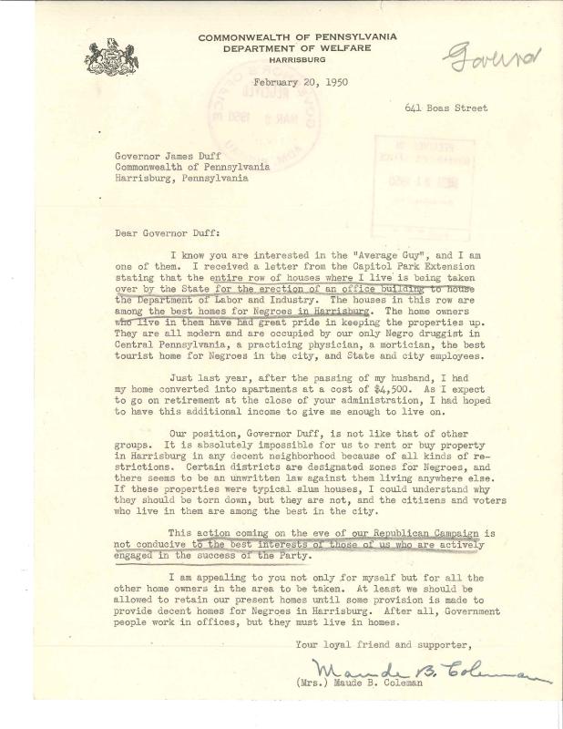
Coleman was born in 1879 and lived briefly in the Old Eighth Ward until 1912, before the First Capitol Extension. Later Coleman lived on Boas Street from 1920 to 1953. The “Maude Coleman Letter,” dated February 20, 1950, was sent to Gov. Duff on the grounds of concern for a friend. As Pennsylvania’s first Interracial Consultant, Coleman looked to appeal to her professional relationship with Duff on behalf of the predominantly African American community located in and around the Second Extension area. While not directly in the extension area, her neighborhood on Boas Street was just one block north of Forster Street and appeared to be the next target for removal from her perspective. Coleman’s letter to Duff prefaced that the conditions for African Americans to acquire (new) housing in Harrisburg were “absolutely impossible” due to unwritten restrictions within the city. Additionally, Coleman pointed out that the homes in the Extension area were not slum houses as the Planning Commission traditionally labeled them. Some of the occupants of this neighborhood included “... our only Negro druggist in Central Pennsylvania, a practicing physician, a mortician, the best tourist home for Negroes in the city, and State and city employees.”
What became of Maude Coleman’s plea for consideration was left unsatisfied and no documents in the Extension Report reference any plans to move to her neighborhood on Boas. Throughout the development process of the First and Second Capitol Extensions came the removal of over 500 properties and countless residents of the 7th and 8th wards. The construction of multiple office buildings, park land, the Pennsylvania State Museum, and the former site of the Pennsylvania State Archives, shrouded the structures of a once-living community now forever lost to time.
A full list of the resources used in this story can be found here.
Related Stories
The Phyllis Wheatley YWCA
A Gathering at the Crossroads
Black Politics and City Beautiful
Images
Documents
| Name | Info | Actions |
|---|---|---|
| The Proposed Extension of the State Capitol Grounds at Harrisburg, Pennsylvania, May 1941 | pdf / 14.83 MB | Download |